The Carboniferous
The Carboniferous succession at Tedbury Camp Quarry is assigned to the Clifton Down Limestone, a formation
that occurs towards the top of the Lower Carboniferous (Dinantian) and is of Holkerian age (Cossey, 2004).
Regional mapping indicates that the formation is about 150m thick, although only 55m is currently exposed in the
quarry. The limestones dip NNW at 45-55° and the intersection of the bedding planes with the unconformity
surface produce a prominent series of linear features across the quarry floor (Figure 6). Dip sections of the
limestone are best seen along the eastern edge of the quarry, although this section is becoming increasingly
overgrown.

Figure 7. Dipping beds of Down Limestone


See also Location 1, for an annotated version
Regional stratigraphic considerations and palaeogeographic reconstructions indicate that the succession was deposited in a
shallow marine environment, probably on a gently dipping carbonate ramp (Wright, 1987). The bioclastic limestones were
probably deposited below normal wave-base, but the abundant transported fossil fragments suggest frequent storm activity,
with occasional regressive phases promoting the development of oolite shoals, thin dolomite bands and algal stromatolites.
Whilst most of the limestone succession dips uniformly northwards, there is a prominent fold near the western edge of the
quarry that is developed in a thinly bedded sequence of limestones and cherts (Figure 5). It is best seen by standing on the
wooded bank above the quarry which provides an oblique ‘aerial’ view (Figure 8). The tight fold axis plunges 38° NNE and is
terminated by an N-S trending tear fault. The beds surrounding the fold are essentially undeformed and thus the fold is very
localised.

Figure 8. Fold in the Clifton Down Limestone
See also Location 3, for an annotated version
It is tempting to correlate the thinly bedded, folded sequence adjacent to the fault with the only other thinly bedded
sequence seen in the quarry, which is exposed in the northeastern corner (Figure 5). Systematic logging of both sequences
would facilitate that correlation which, if established, indicates a sinistral displacement along the N-S tear fault of about
40m. Alternatively, if the sequences do not correlate, the displacement would be >40m, but essentially unquantifiable
because of the lack of exposure beyond the quarry limits.
Another interpretation is that the fold is not related to the fault at all, but is an early, syn-sedimentary slump feature. This has
some appeal because it might explain why the distortion is so localized and why other ‘drag’ features are not seen along the
N-S fault. In this scenario the N-S fault post-dates the fold but exploits an existing line of weakness at its margin, apparently
dying out within a few metres to the north and south (Figure 5).
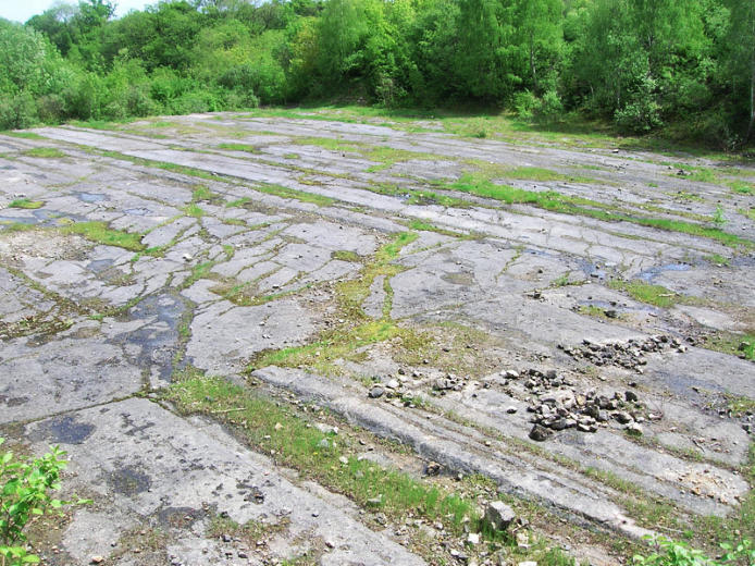
Figure 6. View across the unconformity surface, looking SE
Linear ‘strike lines’produced by the intersection of bedding planes with the horizontal
unconformity surface are picked out by lines of vegetation. See also Panorama SE, for an
annotated version
The succession is dominated by dark grey, massive bioclastic (crinoidal) limestones, typically 30-50cm thick, with
occasional carbonate mudstone and thin dolomitic horizons (Figure 7). Chert occurs throughout as irregular nodules,
lenses and thin, discrete beds, becoming increasingly common in the thinly interbedded limestone, dolomite and chert unit
exposed in the northeast corner of the quarry. Oolitic limestones (Wilson 1994, Figure 3.6) and algal stromatolites (Duff et
al., 1985, page 141) have also been recorded, and fossil horizons are widespread. Solitary and colonial rugose corals
(particularly Lithostrotion), productoid brachipods and crinoid ossicles occur as scattered fragments within the more
massive limestones and occasionally form thin shell beds.