Rivers

Copyright for all materials remains the property of the authors, but you may use it freely for
educational purposes.This site hosted by Geohubliverpool.

What is a river?
A river is a flow of fresh water downwards across the surface of the land. Rivers may flow into lakes, but most flow towards the sea. The river’s source is the place where it begins to flow and the river’s mouth is the place where it ends, usually where it meets the sea. Most of the water flowing in rivers comes from precipitation runoff from the land alongside the river. Water in rivers also comes from springs or seepages of groundwater (rain that originally soaked into the ground) onto the surface. A river flows in a channel. The bottom of the river channel is called the bed and the sides of the channel are called the banks. Size and shape of the river channel change as the river transports water to its mouth. The river increases in size as it flows downstream, the river channel becomes wider and deeper and its cross-sectional area increases. As the river flows towards its mouth greater amounts of water and rock material are carried and the river’s velocity increases.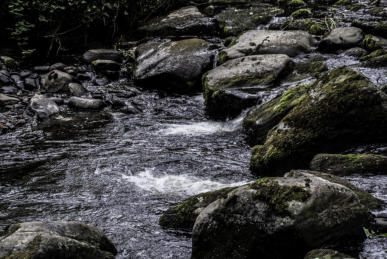
Boulders in a river bed in the Clwydian Hills, North Wales.
Credit: M Williams
Springs in the wall of the Grand Canyon flowing into the
Colorado River, Arizona
Credit: RD MacNish, USGS

River Dee close to its mouth, Chester, Cheshire
Credit: M Williams
River action and the features it produces
River load and transport
The load of a river is the rock material picked up and carried by the river. This material (or sediment) can be transported in four ways: • Solution - when minerals are dissolved in sea water and carried in solution. • Suspension - when small particles (e.g. silt and clay) are carried, never touching the river bed. These fine particles can make the water look cloudy. • Saltation – when the load (e.g. small pieces of rock or large sand grains) is bounced along the river bed. • Traction – when pebbles and larger sand grains are rolled along the river bed.River erosion
Erosion takes place in four main ways: • Corrasive action – this is the wearing away (or abrasion) of the banks and bed of the river channel as boulders, pebbles and sand are rubbed against the sides and bottom of the channel. • Hydraulic action – this is when the current of water in the river pushes against the river banks and causes compression of air trapped in cracks in the banks. This increase in pressure weakens and breaks off pieces of rock or causes collapse of parts of the river bank. • Attrition – this occurs when the pieces of rock in the rivers’ load are broken into smaller pieces as they collide with each other. • Solution – this is when the river water dissolves certain minerals in the river channel. This is related to the chemical composition of the water and the concentration of humic or carbonic acid in the water. (Limestone is particularly prone to this type of erosion) A river’s channel is eroded laterally and vertically. This makes the channel wider and deeper. Close to the source of the river here is little horizontal erosion, but a greater amount of vertical erosion takes place. As the river flows nearer to its mouth the amount of vertical erosion is reduced and more horizontal erosion occurs. River valleys are cut through the rock by the flow of water carrying smaller stones and suspended sediments eroded from upstream. As the river flows along its load abrades or rubs away at any surfaces it contacts. The amount and rate of erosion is partly dependent on the hardness of the rock in the river bed and banks. Softer rocks, such as most sedimentary rocks, erode easily; harder rocks, such as igneous rocks and some metamorphic rocks, erode less easily. The river’s load changes downstream. In the upper course of the river nearest to its source its load consists of larger and more angular rock fragments and grains. As the river moves downstream the fragments in its load become smaller, more rounded and smoother in shape. Nearer to the mouth of the river, the load is mostly very fine sediment or mud. When this material is deposited it is known as alluvium.River deposition
When the velocity of a river decreases a river loses its energy and is unable to carry its load. Material begins to be deposited. Heaviest materials in the load such as large boulders are deposited first. Smaller, lighter materials such as gravel, sand or silt are carried further before they are deposited by the river. Deposition may take place when: • the river’s velocity is reduced after a period of low precipitation • the river enters the sea or a lake • the river overflows its banks and its velocity decreases outside the river channel • there is shallower water on the inside of a river bend. The following animation shows a side view of an area where a river flows into a lake. As the flowing water enters the lake, its velocity decreases and sediment is deposited:Why do rivers curve?
At this site there is an animation explaining why rivers curve rather than flow in a straight line:Upper, middle and lower stages of a river
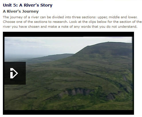
When studying rivers a river is often divided into 3 main sections, the upper course, middle course and lower course. In each of these sections the river shows distinctive landforms as a result of the different erosional and depositional processes at work. The upper course is the section of the river closest to its source; the lower course is the section nearest to its mouth. At this BBC site you can watch clips illustrating the journey of a river from source to mouth and showing the landforms developed in the upper, middle and lower sections of the river:
River features produced by erosion
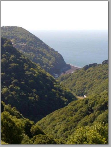
Interlocking spurs and V-shaped valley of the East Lyn, Exmoor,
Somerset
Credit: David Harper
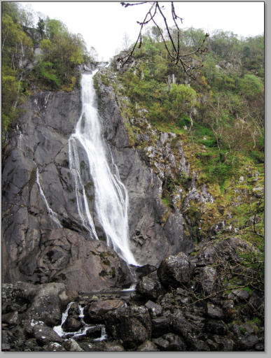
Aber Falls (Rhaeadr Fawr), Gwynedd, Wales.
Credit: M Williams
V-shaped valley and interlocking spurs
V-shaped valleys are formed by erosion in the upper course of a river where there is rapid vertical erosion and a steep-sided valley is formed. At this stage the river is forced to twist and turn around obstacles in its path and interlocking spurs form. The following site gives an explanation of how interlocking spurs form in V- shaped valleys in the upper course of a river: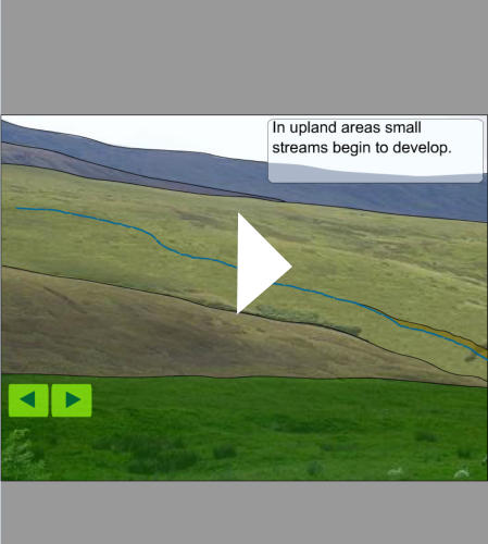
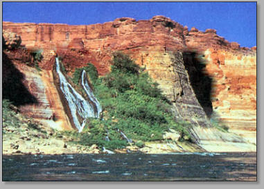
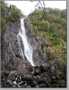
Waterfall
A waterfall is produced as a result of erosion and forms where the river flows over relatively hard rock and then flows across softer rock. The softer rock is eroded more quickly and the river bed is steepened and forms the waterfall. Sometimes the harder rock is undercut as the softer rock is eroded away and may collapse. The link below has a short animation showing how river erosion creates waterfalls: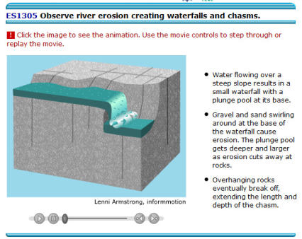
River features produced by deposition
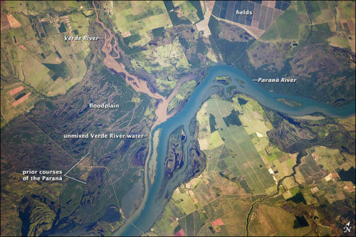

Paraná River floodplain at its confluence with the Verde River, Brazil
Credit: NASA Astronaught image
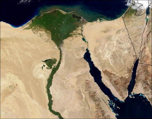
River Nile and delta
Credit: Jacques Descloitres, MOBIS Rapid Response Team,
NASA/GSFC
Flood plains
A river may overflow its banks during times of heavy rain and cover any adjacent flat land. Floodplains are the flat areas susceptible to flooding and as the river spreads over its flood plain it deposits the fine material it carried in suspension. Over the years the alluvium builds up on the flood plain on either side of the river with successive floods. This increases the fertility of the land and builds up the height of the flood plain.Deltas
A delta forms at the mouth of the river as it enters a lake or the sea and the sediment load of the river is deposited. A low-lying swampy plain is built up to form the delta. Coarser sand and silt are deposited first; the finest material is carried furthest in suspension. Deltas provide fertile land, but because they are so flat they are at high risk of flooding. There are three main types of delta, named after the shape they create: • Arcuate or fan-shaped - the land around the river mouth spreads into the sea or lake and creates a fan effect (e.g. Nile delta) • Cuspate - the land around the mouth of the river juts out arrow-like into the sea or lake (e.g. River Tiber delta) • Bird's foot - the river splits on the way its mouth and each part of the river juts out into the mouth so it looks like a bird's foot. (e.g. Mississippi delta)River features produced by deposition and erosion


Meanders of the Rio Cauto in Cuba
Credit: Wikimedia Commons
An oxbow lake in the making, Nowitna River
Credit: Oliver Kurmis
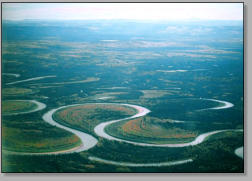
Meanders, point bars and ox bow lakes
A meander is a bend in a river and a point bar is the crescent-shaped depositional feature made of alluvium that collects on the inside bend of the river. An ox bow lake is a U-shaped lake created when a meander is cut off from the main part of the river There is a helpful clip at this site explaining how meanders and oxbow lakes form: https://www.youtube.com/watch?v=4qKS_Nk7UmY

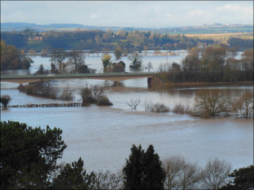
Flooding of rivers
River flooding happens when a river cannot cope with the amount of water draining into it from the surrounding land. It is usually the result of heavy and/or widespread rainfall, but sometimes it is caused by melting snow.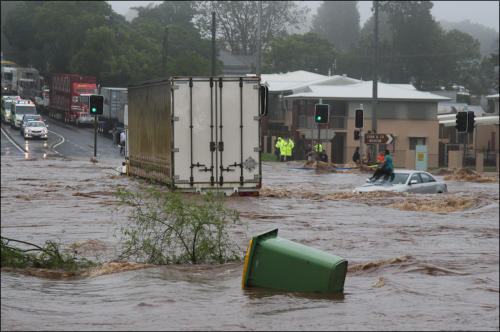

Flash flooding caused by a large amount of rain falling in a
short period of time.
Credit: kingbob86 (Timothy)
Flooding near Ross-on-Wye caused by the rise of the
river level in the River Wye
Credit: M Williams
The Environmental Agency has produced a site where there are interactive maps which show the risk of flooding from rivers and the sea in
different areas:
http://watermaps.environment-agency.gov.uk/wiyby/wiyby.aspx?topic=floodmap#x=357683&y=355134&scale=2
The following BBC clip explains some of the causes and effects of river flooding in Britain and deals with possible damage limitation
methods:
http://www.bbc.co.uk/education/clips/zvycd2p
The Geological Society of London has produced a useful fact sheet about flooding and it is available at the following site:
http://www.geolsoc.org.uk/~/media/shared/documents/education%20and%20careers/flooding%20leaflet%20final%20no%20footer.pdf
Underground water in limestone areas
Caves or caverns
Water can flow across the surface of the land, but can also flow under the ground in the form of underground rivers. In limestone areas the rock is affected by the flow of groundwater charged with H2CO3 (carbonic acid). The limestone, which is composed of calcium carbonate, reacts with this weak acid and produces calcium bicarbonate which is removed in solution. As the groundwater seeps through joints and cracks in the limestone underground caves or caverns may form.Swallow hole
A swallow hole is a basin in a limestone area down which water disappears. Another name for a swallow hole is a sink hole. Gaping Ghyll is a swallow hole in North Yorkshire where the Fell Beck flows into the swallow hole and disappears underground. It holds the record for the tallest unbroken waterfall in England and the largest underground chamber naturally open to the surface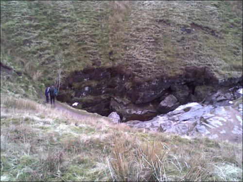

A view of the crater around the mouth of Gaping Ghyll
Credit: Wikipedia
Gaping Ghyll: Entrance shaft viewed from the Main Chamber
Credit: Mark S. Jobling
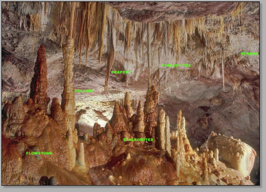
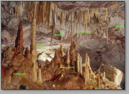
Stalagmites and stalactites
The walls, roof and floors of limestone caves are often covered with calcite formations produced through the slow precipitation of calcium carbonate from the water dripping through the cave. These formations include stalactites and stalagmites. Where water drops from the cave roof, a stalactite is formed. Where the water drops to the floor of the cave a stalagmite is formed. This BBC clip shows the stalactites and stalagmites which have been created by underground water: http://www.bbc.co.uk/education/clips/z7sgkqt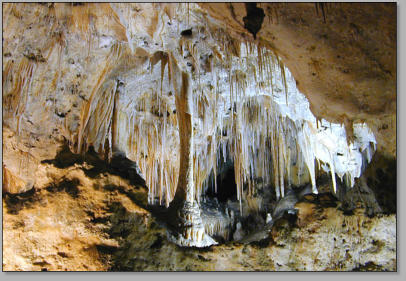
Interior cave formations at Carlsbad Caverns National Park, New
Mexico
Credit: Eric Guinther
The six most common speleothems (mineral deposits formed
from groundwater within underground caverns).
Credit: Dave Bunnell


Further information about rivers
The following BBC website covers how rivers change and includes a useful glossary of terms: http://www.bbc.co.uk/schools/riversandcoasts/rivers/change_river/index.shtml OneGeology is an international initiative of the geological surveys of the world and was a project launched in 2007 to mark the 'International Year of Planet Earth'. This section of the OneGeology site covers rivers and includes some excellent photographs and provides clear explanations of what is illustrated: http://www.onegeology.org/extra/kids/earthprocesses/rivers.html Fantastic resource with lots of interactive simulations about rivers and their formation: http://topicbox.net/geography/rivers/1085/ The Thames Explorer Trust have complied a bank of resources to help you teach about rivers: http://www.thames-explorer.org.uk/thames-education/river-lesson-plans Information about the main rivers in Britain is available from this site: http://www.fatbadgers.co.uk/Britain/rivers.htm


This YouTube video follows the River Severn from
source to mouth:
Rivers

What is a river?
A river is a flow of fresh water downwards across the surface of the land. Rivers may flow into lakes, but most flow towards the sea. The river’s source is the place where it begins to flow and the river’s mouth is the place where it ends, usually where it meets the sea. Most of the water flowing in rivers comes from precipitation runoff from the land alongside the river. Water in rivers also comes from springs or seepages of groundwater (rain that originally soaked into the ground) onto the surface. A river flows in a channel. The bottom of the river channel is called the bed and the sides of the channel are called the banks. Size and shape of the river channel change as the river transports water to its mouth. The river increases in size as it flows downstream, the river channel becomes wider and deeper and its cross-sectional area increases. As the river flows towards its mouth greater amounts of water and rock material are carried and the river’s velocity increases.

Boulders in a river bed in the Clwydian Hills,
North Wales.
Credit: M Williams
Springs in the wall of the Grand Canyon flowing
into the Colorado River, Arizona
Credit: RD MacNish, USGS
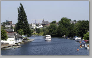
River Dee close to its mouth, Chester, Cheshire
Credit: M Williams
River action and the features it produces
River load and transport
The load of a river is the rock material picked up and carried by the river. This material (or sediment) can be transported in four ways: • Solution - when minerals are dissolved in sea water and carried in solution. • Suspension - when small particles (e.g. silt and clay) are carried, never touching the river bed. These fine particles can make the water look cloudy. • Saltation – when the load (e.g. small pieces of rock or large sand grains) is bounced along the river bed. • Traction – when pebbles and larger sand grains are rolled along the river bed.River deposition
When the velocity of a river decreases a river loses its energy and is unable to carry its load. Material begins to be deposited. Heaviest materials in the load such as large boulders are deposited first. Smaller, lighter materials such as gravel, sand or silt are carried further before they are deposited by the river. Deposition may take place when: • the river’s velocity is reduced after a period of low precipitation • the river enters the sea or a lake • the river overflows its banks and its velocity decreases outside the river channel • there is shallower water on the inside of a river bend. The following animation shows a side view of an area where a river flows into a lake. As the flowing water enters the lake, its velocity decreases and sediment is deposited:Why do rivers curve?
At this site there is an animation explaining why rivers curve rather than flow in a straight line:Upper, middle and lower stages of a river
When studying rivers a river is often divided into 3 main sections, the upper course, middle course and lower course. In each of these sections the river shows distinctive landforms as a result of the different erosional and depositional processes at work. The upper course is the section of the river closest to its source; the lower course is the section nearest to its mouth. At this BBC site you can watch clips illustrating the journey of a river from source to mouth and showing the landforms developed in the upper, middle and lower sections of the river:River erosion
Erosion takes place in four main ways: • Corrasive action – this is the wearing away (or abrasion) of the banks and bed of the river channel as boulders, pebbles and sand are rubbed against the sides and bottom of the channel. • Hydraulic action – this is when the current of water in the river pushes against the river banks and causes compression of air trapped in cracks in the banks. This increase in pressure weakens and breaks off pieces of rock or causes collapse of parts of the river bank. • Attrition – this occurs when the pieces of rock in the rivers’ load are broken into smaller pieces as they collide with each other. • Solution – this is when the river water dissolves certain minerals in the river channel. This is related to the chemical composition of the water and the concentration of humic or carbonic acid in the water. (Limestone is particularly prone to this type of erosion) A river’s channel is eroded laterally and vertically. This makes the channel wider and deeper. Close to the source of the river here is little horizontal erosion, but a greater amount of vertical erosion takes place. As the river flows nearer to its mouth the amount of vertical erosion is reduced and more horizontal erosion occurs. River valleys are cut through the rock by the flow of water carrying smaller stones and suspended sediments eroded from upstream. As the river flows along its load abrades or rubs away at any surfaces it contacts. The amount and rate of erosion is partly dependent on the hardness of the rock in the river bed and banks. Softer rocks, such as most sedimentary rocks, erode easily; harder rocks, such as igneous rocks and some metamorphic rocks, erode less easily. The river’s load changes downstream. In the upper course of the river nearest to its source its load consists of larger and more angular rock fragments and grains. As the river moves downstream the fragments in its load become smaller, more rounded and smoother in shape. Nearer to the mouth of the river, the load is mostly very fine sediment or mud. When this material is deposited it is known as alluvium.


Funded by:
Created by ESTA members: Tracy Atkinson, John Reynolds, Stewart
Taylor, Geoff Selby-Sly, Maggie Williams, Peter Williams
Copyright for all materials remains the property of the authors, but you may use it freely for
educational purposes.


River features produced by erosion

Interlocking spurs and V-shaped valley
of the East Lyn, Exmoor, Somerset
Credit: David Harper
Aber Falls (Rhaeadr Fawr), Gwynedd, Wales.
Credit: M Williams
V-shaped valley and interlocking spurs
V-shaped valleys are formed by erosion in the upper course of a river where there is rapid vertical erosion and a steep-sided valley is formed. At this stage the river is forced to twist and turn around obstacles in its path and interlocking spurs form. The following site gives an explanation of how interlocking spurs form in V- shaped valleys in the upper course of a river:Waterfall
A waterfall is produced as a result of erosion and forms where the river flows over relatively hard rock and then flows across softer rock. The softer rock is eroded more quickly and the river bed is steepened and forms the waterfall. Sometimes the harder rock is undercut as the softer rock is eroded away and may collapse. The link below has a short animation showing how river erosion creates waterfalls:River features produced by deposition
Paraná River floodplain at its confluence with
the Verde River, Brazil
Credit: NASA Astronaught image
River Nile and delta
Credit: Jacques Descloitres, MOBIS
Rapid Response Team, NASA/GSFC
Flood plains
A river may overflow its banks during times of heavy rain and cover any adjacent flat land. Floodplains are the flat areas susceptible to flooding and as the river spreads over its flood plain it deposits the fine material it carried in suspension. Over the years the alluvium builds up on the flood plain on either side of the river with successive floods. This increases the fertility of the land and builds up the height of the flood plain.Deltas
A delta forms at the mouth of the river as it enters a lake or the sea and the sediment load of the river is deposited. A low-lying swampy plain is built up to form the delta. Coarser sand and silt are deposited first; the finest material is carried furthest in suspension. Deltas provide fertile land, but because they are so flat they are at high risk of flooding. There are three main types of delta, named after the shape they create: • Arcuate or fan-shaped - the land around the river mouth spreads into the sea or lake and creates a fan effect (e.g. Nile delta) • Cuspate - the land around the mouth of the river juts out arrow-like into the sea or lake (e.g. River Tiber delta) • Bird's foot - the river splits on the way its mouth and each part of the river juts out into the mouth so it looks like a bird's foot. (e.g. Mississippi delta)River features produced by deposition and erosion

An oxbow lake in the making, Nowitna River
Credit: Oliver Kurmis
Meanders of the Rio Cauto in Cuba
Credit: Wikimedia Commons
Meanders, point bars and ox bow lakes
A meander is a bend in a river and a point bar is the crescent-shaped depositional feature made of alluvium that collects on the inside bend of the river. An ox bow lake is a U-shaped lake created when a meander is cut off from the main part of the river There is a helpful clip at this site explaining how meanders and oxbow lakes form: https://www.youtube.com/watch?v=4qKS_Nk7UmY
Flooding of rivers
River flooding happens when a river cannot cope with the amount of water draining into it from the surrounding land. It is usually the result of heavy and/or widespread rainfall, but sometimes it is caused by melting snow.
Flash flooding caused by a large amount
of rain falling in a short period of time.
Credit: kingbob86 (Timothy)
Flooding near Ross-on-Wye caused by
the rise of the river level in the River
Wye
Credit: M Williams
The Environmental Agency has produced a site where there are interactive maps which
show the risk of flooding from rivers and the sea in different areas:
http://watermaps.environment-
agency.gov.uk/wiyby/wiyby.aspx?topic=floodmap#x=357683&y=355134&scale=2
The following BBC clip explains some of the causes and effects of river flooding in Britain
and deals with possible damage limitation methods:
http://www.bbc.co.uk/education/clips/zvycd2p
The Geological Society of London has produced a useful fact sheet about flooding and it is
available at the following site:
http://www.geolsoc.org.uk/~/media/shared/documents/education%20and%20careers/floodin
g%20leaflet%20final%20no%20footer.pdf
Underground water in limestone areas
Caves or caverns
Water can flow across the surface of the land, but can also flow under the ground in the form of underground rivers. In limestone areas the rock is affected by the flow of groundwater charged with H2CO3 (carbonic acid). The limestone, which is composed of calcium carbonate, reacts with this weak acid and produces calcium bicarbonate which is removed in solution. As the groundwater seeps through joints and cracks in the limestone underground caves or caverns may form.Swallow hole
A swallow hole is a basin in a limestone area down which water disappears. Another name for a swallow hole is a sink hole. Gaping Ghyll is a swallow hole in North Yorkshire where the Fell Beck flows into the swallow hole and disappears underground. It holds the record for the tallest unbroken waterfall in England and the largest underground chamber naturally open to the surface
Gaping Ghyll: Entrance shaft viewed from the
Main Chamber
Credit: Mark S. Jobling
A view of the crater around the mouth of
Gaping Ghyll
Credit: Wikipedia
Stalagmites and stalactites
The walls, roof and floors of limestone caves are often covered with calcite formations produced through the slow precipitation of calcium carbonate from the water dripping through the cave. These formations include stalactites and stalagmites. Where water drops from the cave roof, a stalactite is formed. Where the water drops to the floor of the cave a stalagmite is formed. This BBC clip shows the stalactites and stalagmites which have been created by underground water: http://www.bbc.co.uk/education/clips/z7sgkqt
Interior cave formations at Carlsbad Caverns
National Park, New Mexico
Credit: Eric Guinther
The six most common speleothems (mineral
deposits formed from groundwater within
underground caverns).
Credit: Dave Bunnell


Further information about rivers
The following BBC website covers how rivers change and includes a useful glossary of terms: http://www.bbc.co.uk/schools/riversandcoasts/rivers/change_river/index.shtml OneGeology is an international initiative of the geological surveys of the world and was a project launched in 2007 to mark the 'International Year of Planet Earth'. This section of the OneGeology site covers rivers and includes some excellent photographs and provides clear explanations of what is illustrated: http://www.onegeology.org/extra/kids/earthprocesses/rivers.html Fantastic resource with lots of interactive simulations about rivers and their formation: http://topicbox.net/geography/rivers/1085/ The Thames Explorer Trust have complied a bank of resources to help you teach about rivers: http://www.thames-explorer.org.uk/thames-education/river-lesson-plans Information about the main rivers in Britain is available from this site: http://www.fatbadgers.co.uk/Britain/rivers.htm


This YouTube video follows
the River Severn from source
to mouth: