Coasts


Funded by:
Created by ESTA members: Tracy Atkinson, John Reynolds, Stewart
Taylor, Geoff Selby-Sly, Maggie Williams, Peter Williams
Copyright for all materials remains the property of the authors, but you may use it freely for
educational purposes. This site hosted by Geohubliverpool.
Coastline
The area where land meets the sea or ocean is a coastline or seashore. In the United Kingdom
the coastline is very varied. The distinctive features on the coastline are the result of the
processes of coastal erosion, transportation and deposition. These processes are affected by
waves, tidal currents and longshore currents and the nature of the rocks on the coast.
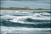
Waves
Waves are generated by wind blowing across the surface of the sea. Large waves develop
when strong, steady winds blow over the huge expanses of ocean. Once formed, waves can
travel many kilometres. When the sea becomes shallower near coasts, the wave is disturbed,
its top falls forward and the wave breaks. The water thrown up the beach by breaking waves
is called the swash. The water that drains back is called the backwash.
Tides
Tides are the regular rise and fall of sea levels caused by the combined effects of the gravitational forces exerted by the Moon and the
Sun and the rotation of the Earth. In a particular place, tides usually happen twice each day at a predictable time.
What causes tides?
Gravity attracts all physical objects towards each other and the bigger the object, the greater its gravitational force. Although the Sun
has a greater mass than the Moon, the Moon is nearer to the Earth and so it has the greatest influence on the Earth. The Moon’s
gravitational pull on the Earth pulls the water contained in oceans and seas to the side of the Earth nearest to the Moon. This causes a
tidal bulge or high tide of water, which moves around the Earth, following the Moon’s orbit. A tidal bulge also occurs at the opposite side
of the Earth to the Moon. It is this matching bulge that causes two tides each day.
Why are some tides higher than others?
The Sun’s smaller gravitational attraction also influences the
tides, but not as much as the Moon because it is so much
further away from Earth. This attraction causes the
difference in tidal range. However, when the Sun and Moon are
in line with the Earth their gravitational forces are added
together and they pull the water into bigger bulges known as a
spring tides. Spring tides produce the highest high tides and
lowest low tides. Spring tides reach their peak every 14 days.
Spring tides (the highest high and lowest low tides) occur at
full and new moons, when the sun and moon are in line with each
other. As the Earth rotates each day the tidal bulges
effectively move around the globe with the highest part causing
two very high tides and the shallowest part causing the very low tides.
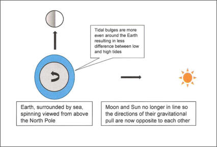

When the Sun and Moon are not in line their gravitational forces acting on the Earth are pulling in different directions, so their
effects on the tides are reduced. Although there are still two tides daily, the differences between high and low tides are not as
great. These are called neap tides.
Neap tides occur when there is a half moon and the sun and
moon are not in line with each other. They both pull some of
the water in the oceans towards them but they act in
opposite directions. The water pulled towards the moon
causes the higher of the neap tides as the moon has a greater
gravitational influence. There is not as much difference
between neap high and low tides.

“I do not know what I may
appear to the world, but to
myself I seem to have been
only like a boy playing on the
seashore, and diverting
myself in now and then
finding a smoother pebble
or a prettier shell than
ordinary, whilst the great
ocean of truth lay all
undiscovered before me.”
Isaac Newton, 1687
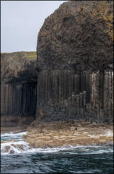
Coastal erosion
Erosion on the coast is caused by wave action. Wave erosion takes place in three main ways:
Corrasive action – this is the wearing away of the base of a cliff as boulders, pebbles and sand are thrown against the cliff.
Hydraulic action – this is when water impacts against the face of a cliff and causes air trapped in the cracks rock to be
compressed. This increase in pressure weakens and breaks off pieces of rock.
Attrition – this occurs when the rocks already broken from the cliff face are broken into smaller pieces.
Landforms produced by erosion
Cliffs and wave-cut platforms
Cliffs are high, steep faces of rock on the coastline. These rock faces often rise vertically and formed as a
result of the regular pounding by waves loaded with pebbles and sand. The waves batter the base of cliffs and
undercut them, cutting out notches and hollows, and exploit lines of weakness. This eventually causes the rocks
above to collapse into the sea. The waves continue to batter the fallen rocks, eventually reducing the size of
the fragments and carrying away the smaller ones. Gently sloping rock platforms, or wave-cut platforms, are
often formed at the base of cliffs as the cliffs are pushed back or retreat. Wave-cut platforms may only be
visible at low tide and their landward edges may be covered in sediments, forming beaches. Wave-cut
platforms are usually very uneven, as waves and pebbles gouge hollows out. At low tide these hollows become
rock pools which can be full of a huge variety of sea plants and animals.
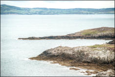
Headlands and bays
Headlands and bays are often found on the same coastline in areas where there are areas of
alternating resistant and ess resistant rock. Headlands are sea cliffs surrounded by water on three
sides which protrude out into the sea because the rocks they are made from are more resilient to
erosion. A bay is surrounded by land on three sides. Bays form where less resistant rock is worn
away faster. Bays typically have sandy beaches. Material eroded from the headlands tends to be
deposited in the bays.
Sea Caves
A sea cave is a tunnel which extends into the base of a cliff. The tunnel diameter decreases in diameter from the entrance. The cave
forms when waves erode along a line of weakness in the cliff rocks. Waves are very good at attacking any weaknesses in a rock, such as
cracks (joints) and faults.
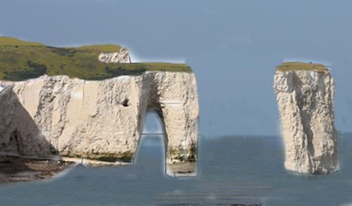
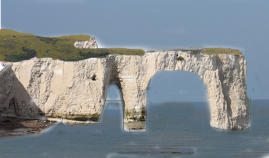
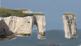
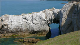
Arches, stacks and stumps
An arch forms when caves develop on both sides of a headland as waves erode along a line of weakness
that runs through the headland. The two caves eventually erode into the back of each other forming an
arch that passes right through the headland. A combination of wave attack at the base of the arch and
weathering of the roof of the arch weakens the structure until eventually the roof of the arch collapses
leaving a stack or a column of rock which is separated from the rest of the headland. The stack will
continue to be eroded and when it collapses it forms a stump, the eroded remains of the stack, which
forms low column of rock that will be covered by water at high tide.
Blow holes
Blow holes are holes that appear in the top of a cliff and which can spout water, especially when the sea is rough and/or the tide is high.
A blowhole is formed as sea caves grow landwards and upwards into vertical shafts and expose themselves towards the surface.
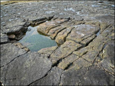
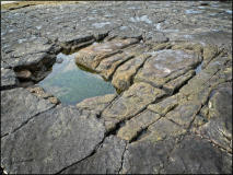
Rock pools
Wave-cut platforms are usually very uneven, as waves and pebbles gouge hollows out of the rock surface.
At low tide these hollows become rock pools or tide pools which are filled with seawater and can be full of
a huge variety of sea plants and animals. These pools exist as separate pools only at low tide. As the tide
rises the pools becomes connected to the main body of water allowing access in and out of the pool at high
tide, but isolation at periods of low tide. This influences the types of fauna that choose to inhabit the
pools. The conditions in the rock pool environment are constantly changing. Changes that are evened out
in larger bodies of water are amplified in rock pools. Light will vary during the day, oxygen will be used,
during low tide temperature will build up or reduce depending on the weather conditions and salinity
(saltiness) will vary according to rates of evaporation and the amount of rainfall. Many types of seaweed,
small fish, crabs, shrimp, jellyfish, starfish, molluscs, bivalves, anemones and marine snails are some of
the creatures that can be found in addition to various larger fish that may be temporarily trapped in the
pools by receding tides.
Coastal transport and deposition
Transport by waves and tidal currents
The load is the rock material carried by waves and tidal currents. This
material (or sediment), which has been eroded from the cliffs or
transported along the coastline, can be transported in four ways:
Solution - when minerals are dissolved in sea water and carried in
solution.
Suspension - when small particles (e.g. silt and clay) are carried in
suspension. These fine particles can make the water look cloudy.
Saltation – when the load (e.g. small pieces of rock or large sand
grains) is bounced along the sea bed.
Traction – when pebbles and larger sand grains are rolled along
the sea bed.
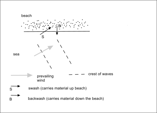
Waves can be constructive or destructive. For a constructive wave, the
swash is stronger than the backwash and these waves cause sediment to be
built up above low water mark. With a destructive wave, the backwash is
stronger than the swash. These waves are more likely to carry material down
the beach and deposit it below the low water mark.
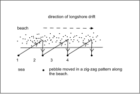
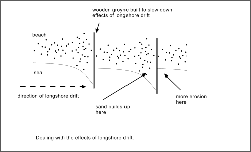
Waves usually approach the coast at a slight angle. This angle is determined by the
direction of the prevailing wind. The swash carries material obliquely up the beach and
the backwash carries material directly down the beach and back to the sea. This
process of longshore drift is capable of moving large quantities of sediment along a
beach.
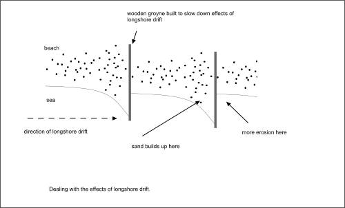
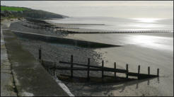
To reduce the loss of beach sand by longshore drift, groynes
are often built across the beach to limit the distance the
sand can be transported.
Landforms produced by deposition
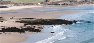
Beaches
Beaches are temporary deposits of material consisting of boulders, pebbles, gravel, sand, mud and shells. Beaches are always moving from
one place to another. Some of this material has been eroded and transported by rivers to
the coast; other material has been formed by erosion of cliffs along the coastline. All
have been moved along the coast by waves, currents and tides. During this time, the
material is being rounded and reduced in size and sorted by wave action. The type of
beach (sand or pebble) depends on the surrounding geology and the wave energy. Sand
beaches have gently sloping profile and pebble or shingle beaches are steeper.
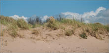
Sand Dunes
Sand dunes can develop at the back of many beaches on exposed coasts. Wind blowing
onshore across large expanses of sandy beach can easily pick up the finer sand grains and
transport them some distance inland. Attempts are often made to restrict the movement
of coastal dunes by:
planting marram grass and other deep rooting plants,
erecting picket fencing
laying slatted wooden footpaths to the beach.
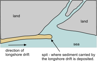
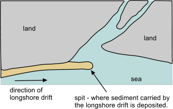
Spits
A spit is a depositional landform developed at a headland when longshore drift moves sand
and is no longer able to carry the full load and much of the sediment is dropped or
deposited


Credit: M. Williams
Credit: M. Williams
Credit: M. Williams
Credit: M. Williams
Credit: M. Williams
Credit: M. Williams

Credit: M. Williams
Credit: M. Williams


Coasts
Funded by:
Created by ESTA members: Tracy Atkinson, John Reynolds, Stewart
Taylor, Geoff Selby-Sly, Maggie Williams, Peter Williams
Copyright for all materials remains the property of the authors, but you may use it freely for
educational purposes.
Coastline
The area where land meets the sea or ocean is a coastline or
seashore. In the United Kingdom the coastline is very varied.
The distinctive features on the coastline are the result of the
processes of coastal erosion, transportation and deposition.
These processes are affected by waves, tidal currents and
longshore currents and the nature of the rocks on the coast.
Waves
Waves are generated by wind blowing across the surface of the sea. Large waves develop when
strong, steady winds blow over the huge expanses of ocean. Once formed, waves can travel
many kilometres. When the sea becomes shallower near coasts, the wave is disturbed, its top
falls forward and the wave breaks. The water thrown up the beach by breaking waves is called
the swash. The water that drains back is called the backwash.
Tides
Tides are the regular rise and fall of sea levels caused by the combined effects of the
gravitational forces exerted by the Moon and the Sun and the rotation of the Earth. In a
particular place, tides usually happen twice each day at a predictable time.
What causes tides?
Gravity attracts all physical objects towards each other and the bigger the object, the greater
its gravitational force. Although the Sun has a greater mass than the Moon, the Moon is nearer
to the Earth and so it has the greatest influence on the Earth. The Moon’s gravitational pull on
the Earth pulls the water contained in oceans and seas to the side of the Earth nearest to the
Moon. This causes a tidal bulge or high tide of water, which moves around the Earth, following
the Moon’s orbit. A tidal bulge also occurs at the opposite side of the Earth to the Moon. It is
this matching bulge that causes two tides each day.
Why are some tides higher than others?
The Sun’s smaller gravitational attraction also influences the tides, but not as much as the Moon
because it is so much further away from Earth. This attraction causes the difference in tidal
range. However, when the Sun and Moon are in line with the Earth their gravitational forces
are added together and they pull the water into bigger bulges known as a spring tides. Spring
tides produce the highest high tides and lowest low tides. Spring tides reach their peak every
14 days.
Spring tides (the highest high and lowest
low tides) occur at full and new moons,
when the sun and moon are in line with
each other. As the Earth rotates each
day the tidal bulges effectively move
around the globe with the highest part
causing two very high tides and the
shallowest part causing the very low
tides.

When the Sun and Moon are not in line their gravitational forces acting on the Earth are
pulling in different directions, so their effects on the tides are reduced. Although there
are still two tides daily, the differences between high and low tides are not as great.
These are called neap tides.

Neap tides occur when there is a half
moon and the sun and moon are not in line
with each other. They both pull some of
the water in the oceans towards them but
they act in opposite directions. The water
pulled towards the moon causes the higher
of the neap tides as the moon has a
greater gravitational influence. There is
not as much difference between neap high
and low tides.

“I do not know what I may appear to the world,
but to myself I seem to have been only like a boy
playing on the seashore, and diverting myself in
now and then finding a smoother pebble or a
prettier shell than ordinary, whilst the great
ocean of truth lay all undiscovered before me.”
Isaac Newton, 1687

Coastal erosion
Erosion on the coast is caused by wave action. Wave erosion takes place in three main ways:
Corrasive action – this is the wearing away of the base of a cliff as boulders, pebbles
and sand are thrown against the cliff.
Hydraulic action – this is when water impacts against the face of a cliff and causes air
trapped in the cracks rock to be compressed. This increase in pressure weakens and
breaks off pieces of rock.
Attrition – this occurs when the rocks already broken from the cliff face are broken
into smaller pieces.
Landforms produced by erosion
Cliffs and wave-cut platforms
Cliffs are high, steep faces of rock on the coastline. These rock
faces often rise vertically and formed as a result of the regular
pounding by waves loaded with pebbles and sand. The waves
batter the base of cliffs and undercut them, cutting out notches
and hollows, and exploit lines of weakness. This eventually causes
the rocks above to collapse into the sea. The waves continue to
batter the fallen rocks, eventually reducing the size of the
fragments and carrying away the smaller ones. Gently sloping
rock platforms, or wave-cut platforms, are often formed at the
base of cliffs as the cliffs are pushed back or retreat. Wave-cut
platforms may only be visible at low tide and their landward
edges may be covered in sediments, forming beaches. Wave-cut
platforms are usually very uneven, as waves and pebbles gouge
hollows out. At low tide these hollows become rock pools which
can be full of a huge variety of sea plants and animals.
Headlands and bays
Headlands and bays are often found on the same
coastline in areas where there are areas of alternating
resistant and ess resistant rock. Headlands are sea
cliffs surrounded by water on three sides which
protrude out into the sea because the rocks they are
made from are more resilient to erosion. A bay is
surrounded by land on three sides. Bays form where
less resistant rock is worn away faster. Bays typically
have sandy beaches. Material eroded from the
headlands tends to be deposited in the bays.
Sea Caves
A sea cave is a tunnel which extends into the base of a cliff. The tunnel diameter decreases in
diameter from the entrance. The cave forms when waves erode along a line of weakness in the
cliff rocks. Waves are very good at attacking any weaknesses in a rock, such as cracks (joints)
and faults.
Arches, stacks and stumps
An arch forms when caves develop on both sides of
a headland as waves erode along a line of weakness
that runs through the headland. The two caves
eventually erode into the back of each other
forming an arch that passes right through the
headland. A combination of wave attack at the base
of the arch and weathering of the roof of the arch
weakens the structure until eventually the roof of
the arch collapses leaving a stack or a column of
rock which is separated from the rest of the
headland. The stack will continue to be eroded and when it collapses it
forms a stump, the eroded remains of the stack, which forms low column of rock that will be
covered by water at high tide.
Blow holes
Blow holes are holes that appear in the top of a cliff and which can spout water, especially when
the sea is rough and/or the tide is high. A blowhole is formed as sea caves grow landwards and
upwards into vertical shafts and expose themselves towards the surface.
Rock pools
Wave-cut platforms are usually very uneven, as waves and
pebbles gouge hollows out of the rock surface. At low
tide these hollows become rock pools or tide pools which
are filled with seawater and can be full of a huge variety
of sea plants and animals. These pools exist as separate
pools only at low tide. As the tide rises the pools becomes
connected to the main body of water allowing access in
and out of the pool at high tide, but isolation at periods of
low tide. This influences the types of fauna that choose
to inhabit the pools. The conditions in the rock pool
environment are constantly changing. Changes that are
evened out in larger bodies of water are amplified in rock pools. Light will vary during the day,
oxygen will be used, during low tide temperature will build up or reduce depending on the
weather conditions and salinity (saltiness) will vary according to rates of evaporation and the
amount of rainfall. Many types of seaweed, small fish, crabs, shrimp, jellyfish, starfish,
molluscs, bivalves, anemones and marine snails are some of the creatures that can be found in
addition to various larger fish that may be temporarily trapped in the pools by receding tides.
Coastal transport and deposition
Transport by waves and tidal currents
The load is the rock material carried
by waves and tidal currents. This
material (or sediment), which has
been eroded from the cliffs or
transported along the coastline, can
be transported in four ways:
Solution - when minerals are
dissolved in sea water and
carried in solution.
Suspension - when small
particles (e.g. silt and clay)
are carried in suspension.
These fine particles can
make the water look cloudy.
Saltation – when the load (e.g. small pieces of rock or large sand grains) is bounced along
the sea bed.
Traction – when pebbles and larger sand grains are rolled along the sea bed.
Waves can be constructive or destructive. For
a constructive wave, the swash is stronger
than the backwash and these waves cause
sediment to be built up above low water mark.
With a destructive wave, the backwash is
stronger than the swash. These waves are
more likely to carry material down the beach
and deposit it below the low water mark.
Waves usually approach the coast at a slight angle.
This angle is determined by the direction of the
prevailing wind. The swash carries material
obliquely up the beach and the backwash carries
material directly down the beach and back to the
sea. This process of longshore drift is capable of
moving large quantities of sediment along a beach.
To reduce the loss of beach sand by longshore drift, groynes are often built across the beach
to limit the distance the sand can be transported.
Landforms produced by deposition
Beaches
Beaches are temporary deposits of material consisting
of boulders, pebbles, gravel, sand, mud and shells.
Beaches are always moving from one place to another.
Some of this material has been eroded and
transported by rivers to the coast; other material has
been formed by erosion of cliffs along the coastline.
All have been moved along the coast by waves,
currents and tides. During this time, the material is
being rounded and reduced in size and sorted by wave action. The type of
beach (sand or pebble) depends on the surrounding geology and the wave energy. Sand beaches
have gently sloping profile and pebble or shingle beaches are steeper.
Sand Dunes
Sand dunes can develop at the back of many beaches
on exposed coasts. Wind blowing onshore across large
expanses of sandy beach can easily pick up the finer
sand grains and transport them some distance inland.
Attempts are often made to restrict the movement of
coastal dunes by:
planting marram grass and other deep rooting
plants,
erecting picket fencing
laying slatted wooden footpaths to the beach.
Spits
A spit is a depositional landform developed at a headland when longshore drift moves sand and
is no longer able to carry the full load and much of the sediment is dropped or deposited


Credit: M. Williams
Credit: M. Williams
Credit: M. Williams
Credit: M. Williams
Credit: M. Williams
Credit: M. Williams
Credit: M. Williams
Credit: M. Williams